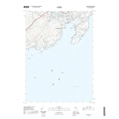
2021 Map of Gloucester
USGS Topo · Published 2021About this map
Gloucester occupies a jagged, boulder-strewn coastline where the Massachusetts shore meets the open Atlantic Ocean. The topography is defined by high points like Heap of Rocks Hill and Wolf Hill, which descend into a network of freshwater bodies including Fernwood Lake and the interconnected Upper Banjo Pond and Lower Banjo Pond. The maritime character of the settlement is evident in the infrastructure, most notably the Blynman Drawbridge which provides vital passage for vessels moving through the harbor. Local history and genealogy are deeply etched into the landscape through numerous well-preserved sites such as the First Parish Burial Ground and several large cemeteries like Oak Grove Cem and Mount Pleasant Cem. Along the periphery, the rugged granite shoreline is punctuated by notable geological features like Rafes Chasm and the protected waters of Southeast Harbor.
Find a feature on this map
88 named features on this map. Tap any name to fly to it.
Don’t see what you’re looking for? This feature index may not catch every label — zoom into the map to look around manually.
Map Details
Editions of this 2021 Gloucester Map
This is the sole edition of this map. No revisions or reprints were ever made.
Other maps of this area

1886 · Gloucester
USGS Topo · 1:62,500

1888 · Gloucester
USGS Topo · 1:62,500

1888 · Salem
USGS Topo · 1:62,500

1892 · Boston Bay
USGS Topo · 1:62,500

1893 · Salem
USGS Topo · 1:62,500

1893 · Gloucester
USGS Topo · 1:62,500

1903 · Boston Bay
USGS Topo · 1:62,500

1917 · Salem
USGS Topo · 1:62,500

1918 · Gloucester
USGS Topo · 1:62,500

1919 · Salem
USGS Topo · 1:62,500