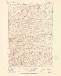
1951 Map of Gobblers Knob
USGS Topo · Published 1953About this map
Hansen Ranch and Ward Ranch anchor the northern landscape of this Park County survey, which documents the complex ranching and mining terrain of the early 1950s. The map illustrates a high-altitude economy where water management was paramount, evidenced by the Brackett Ditch and a Flume along the southern waterways. In the shadow of Gobblers Knob, the land transitions from the established Gallatin National Forest boundary into rugged canyons and draws. Mining history is preserved through several Inactive Mines scattered near Canyon Creek, while the presence of the Terry Sheep Camp highlights the seasonal livestock operations typical of the era. The drainage network is particularly detailed, tracing the confluence of the North Fork, Middle Fork, and South Fork Willow Creek as they descend toward the ranchlands.
Find a feature on this map
28 named features on this map. Tap any name to fly to it.
Don’t see what you’re looking for? This feature index may not catch every label — zoom into the map to look around manually.
Map Details
Editions of this 1951 Gobblers Knob Map
4 editions found
Other maps of this area

1891 · Livingston
USGS Topo · 1:250,000

1893 · Livingston
USGS Topo · 1:250,000

1947 · Bozeman
USGS Topo · 1:250,000

1948 · Bozeman
USGS Topo · 1:250,000

1951 · Bozeman Pass
USGS Topo · 1:62,500

1951 · Gobblers Knob
USGS Topo · 1:24,000

1951 · Clyde Park
USGS Topo · 1:24,000

1951 · Chadborn
USGS Topo · 1:24,000

1951 · Hoppers
USGS Topo · 1:24,000
1951 · Wilsall
USGS Topo · 1:24,000