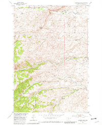
1951 Map of Gobblers Knob
USGS Topo · Published 1982About this map
Gobblers Knob rises as a central landmark in this high-elevation landscape of Park County, Montana, as documented during the early 1950s. The terrain is defined by the headwaters of numerous drainages, including the North Fork, Middle Fork, and South Fork of Willow Creek, which carve through the southern portion of the sheet. The northern reaches are shaped by Brackett Creek and Canyon Creek. Evidence of early agricultural and livestock operations is visible through several named homesteads and facilities, such as the Gibson Ranch, Scott Ranch, and the Terry Sheep Camp. This mid-century survey also captures the industrial footprint of the era with multiple locations marked as Mine (inactive), indicating a shift away from earlier extraction activities. The western edge of the map is dominated by the Gallatin National Forest, delineated by a clear Forest Boundary.
Find a feature on this map
25 named features on this map. Tap any name to fly to it.
Don’t see what you’re looking for? This feature index may not catch every label — zoom into the map to look around manually.
Map Details
Editions of this 1951 Gobblers Knob Map
4 editions found
Other maps of this area

1891 · Livingston
USGS Topo · 1:250,000

1893 · Livingston
USGS Topo · 1:250,000

1947 · Bozeman
USGS Topo · 1:250,000

1948 · Bozeman
USGS Topo · 1:250,000

1951 · Bozeman Pass
USGS Topo · 1:62,500

1951 · Gobblers Knob
USGS Topo · 1:24,000

1951 · Clyde Park
USGS Topo · 1:24,000

1951 · Chadborn
USGS Topo · 1:24,000

1951 · Hoppers
USGS Topo · 1:24,000
1951 · Wilsall
USGS Topo · 1:24,000