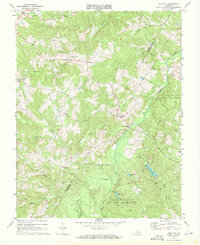
1968 Map of Gold Hill
USGS Topo · Published 1971About this map
The Willis River carves a winding path through the heart of this central Virginia landscape, defining the boundary between Buckingham and Cumberland counties. This late-1960s survey captures a rural region deeply integrated with the Cumberland State Forest, where timberlands are punctuated by quiet settlements and numerous country churches that served as local anchors. Landmarks like New Hope Ch, Petersville Ch, and Jones Chapel stand near narrow roads such as Bell Road and Jim Birch Road, tracing the lineage of established family communities. To the south, recreational waters like Bear Creek Lake, Winston Lake, and Arrowhead Lake highlight the area's transition into a managed forest and conservation space. From the titular Gold Hill in the northwest to the crossroads at Trents Mill, the map documents a traditional Piedmont economy where agriculture and forestry meet along the creek-fed hills.
Find a feature on this map
39 named features on this map. Tap any name to fly to it.
Don’t see what you’re looking for? This feature index may not catch every label — zoom into the map to look around manually.
Map Details
Editions of this 1968 Gold Hill Map
4 editions found
Other maps of this area

1891 · Palmyra
USGS Topo · 1:125,000

1891 · Farmville
USGS Topo · 1:125,000

1893 · Farmville
USGS Topo · 1:125,000

1895 · Palmyra
USGS Topo · 1:125,000

1897 · Palmyra
USGS Topo · 1:125,000

1947 · Roanoke
USGS Topo · 1:250,000

1950 · Dillwyn
USGS Topo · 1:62,500

1958 · Farmville
USGS Topo · 1:62,500

1958 · Jetersville
USGS Topo · 1:62,500

1958 · Dillwyn
USGS Topo · 1:62,500