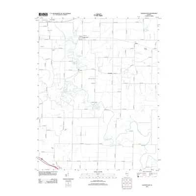
2012 Map of Golden Gate
USGS Topo · Published 2012About this map
Golden Gate and the surrounding prairie of Wayne County, Illinois, are defined by the winding course of the Little Wabash River and a legacy of natural resource extraction. The northern portion of the map is dominated by the Golden Gate Oil Field, situated between Golden Gate and Scottsville, illustrating the local industrial footprint. The landscape transitions from the river's intricate backwaters, such as Half Moon Pond and Horseshoe Pond, to the open stretches of Burks Prairie near Ellery. Genealogists will find a high density of burial sites scattered throughout this rural landscape, including Wilson Cem, Gash Cem, and Antioch Cem. The complex drainage system is evident through numerous engineered features like the Randolph Drainage Ditch and the Gum Road Ditch, which manage the low-lying terrain alongside older landmarks like Hodgson Bridge and Tait Bridge.
Find a feature on this map
73 named features on this map. Tap any name to fly to it.
Don’t see what you’re looking for? This feature index may not catch every label — zoom into the map to look around manually.
Map Details
Editions of this 2012 Golden Gate Map
This is the sole edition of this map. No revisions or reprints were ever made.
Other maps of this area

1940 · Carmi
USGS Topo · 1:62,500

1941 · Enfield
USGS Topo · 1:62,500

1943 · Carmi
USGS Topo · 1:62,500

1943 · Albion
USGS Topo · 1:62,500

1944 · Enfield
USGS Topo · 1:62,500

1946 · Albion
USGS Topo · 1:62,500

1948 · Fairfield
USGS Topo · 1:62,500

1958 · Belleville
USGS Topo · 1:250,000

1962 · Belleville
USGS Topo · 1:250,000
1971 · Golden Gate
USGS Topo · 1:24,000