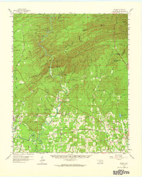
1959 Map of Golden
USGS Topo · Published 1965About this map
The Glover River cuts a deep path through the Ouachita foothills of McCurtain County, dividing the map between the high ridges of Carter Mountain and the agricultural settlements to the south. In the late 1950s, the region was defined by its timber and rail connections, with the Industrial Railroad and the Kirk Little Rock line serving the industrial hub at Wright City. The landscape is dotted with small community centers like Golden and Oak Hill, often centered around rural schools such as Herndon Sch and Glover Sch. Genealogists will find a wealth of local landmarks, including several historic churches and cemeteries like Naniah Chito Ch and Lukfata Cem. The influence of the river is evident in the many family-named landforms, from Shuler Bend to Thompson Bend, and the various springs like Brigham Young Springs that feed into the larger creek systems.
Find a feature on this map
90 named features on this map. Tap any name to fly to it.
Don’t see what you’re looking for? This feature index may not catch every label — zoom into the map to look around manually.
Map Details
Editions of this 1959 Golden Map
2 editions found

Other maps of this area

1901 · Alikchi
USGS Topo · 1:125,000

1902 · Lukfata
USGS Topo · 1:125,000

1950 · Mcalester
USGS Topo · 1:250,000

1950 · Idabel
USGS Topo · 1:24,000

1950 · Shults
USGS Topo · 1:24,000

1951 · Idabel
USGS Topo · 1:24,000

1951 · Garvin
USGS Topo · 1:24,000

1951 · Shults
USGS Topo · 1:24,000

1951 · Millerton
USGS Topo · 1:24,000

1953 · Texarkana
USGS Topo · 1:250,000