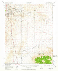
1952 Map of Goldfield
USGS Topo · Published 1964About this map
The high desert of Esmeralda and Nye Counties reveals a landscape defined by its mining heritage and a stark transition to mid-century military use. The town of Goldfield serves as the primary hub, surrounded by a dense concentration of shafts and workings including the Silver Pick Mine and Florence Mine. This 1952 survey documents the region's industrial remains, such as the Columbia Mill (Ruin) and various Tailings piles, which mark the legacy of the early 20th-century gold rush.
Find a feature on this map
43 named features on this map. Tap any name to fly to it.
Don’t see what you’re looking for? This feature index may not catch every label — zoom into the map to look around manually.
Map Details
Editions of this 1952 Goldfield Map
4 editions found
Other maps of this area

1908 · Kawich
USGS Topo · 1:250,000

1908 · Lida
USGS Topo · 1:250,000

1913 · Lida
USGS Topo · 1:250,000

1942 · Tolicha Peak
USGS Topo · 1:125,000

1942 · Cactus Range
USGS Topo · 1:125,000

1945 · Goldfield
USGS Topo · 1:125,000

1952 · Cactus Spring
USGS Topo · 1:62,500

1952 · Mud Lake
USGS Topo · 1:62,500

1952 · Goldfield
USGS Topo · 1:62,500

1952 · Cactus Peak
USGS Topo · 1:62,500