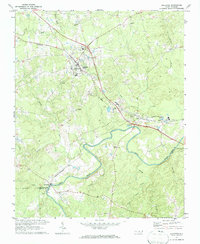
1970 Map of Goldston
USGS Topo · Published 1972About this map
The Deep River carves a winding path across this 1970 snapshot of the North Carolina interior, defining the borders where Chatham, Moore, and Lee counties meet. The industrial character of the era is evident in the Claypits and Quarry operations clustered near Gulf and Goldston, where the Southern and Norfolk Southern railroads intersect to serve the region's mineral and clay works. Small-town civic life is anchored by a dense network of rural landmarks, including Walters Sch and several country sanctuaries such as Antioch Ch, Bethlehem Ch, and Mt Herman Ch. Along the riverbanks near Carbonton, the presence of a Boat Ramp suggests the waterway's transition from an industrial artery to a site for local recreation and transit.
Find a feature on this map
35 named features on this map. Tap any name to fly to it.
Don’t see what you’re looking for? This feature index may not catch every label — zoom into the map to look around manually.
Map Details
Editions of this 1970 Goldston Map
3 editions found
Other maps of this area

1953 · Raleigh
USGS Topo · 1:250,000

1954 · Raleigh
USGS Topo · 1:250,000

1969 · Siler City
USGS Topo · 1:24,000

1970 · Goldston
USGS Topo · 1:24,000

1970 · Pittsboro
USGS Topo · 1:24,000

1970 · Colon
USGS Topo · 1:24,000

1970 · Bear Creek
USGS Topo · 1:24,000

1970 · Siler City NE
USGS Topo · 1:24,000

1974 · White Hill
USGS Topo · 1:24,000

1974 · Putnam
USGS Topo · 1:24,000