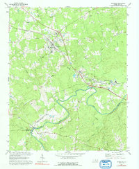
1970 Map of Goldston
USGS Topo · Published 1992About this map
The Deep River curves across this landscape at the intersection of Chatham, Lee, and Moore counties, anchoring a region defined by industrial extraction and small rural congregations. The town of Goldston serves as a central hub, where the Southern railway line meets local landmarks like the Walters Sch and Mt Herman Ch. To the southeast, the settlement of Gulf highlights the area's geological utility with numerous Claypits and a Filtration Plant positioned near the riverbanks.
Find a feature on this map
34 named features on this map. Tap any name to fly to it.
Don’t see what you’re looking for? This feature index may not catch every label — zoom into the map to look around manually.
Map Details
Editions of this 1970 Goldston Map
3 editions found
Other maps of this area

1953 · Raleigh
USGS Topo · 1:250,000

1954 · Raleigh
USGS Topo · 1:250,000

1969 · Siler City
USGS Topo · 1:24,000

1970 · Goldston
USGS Topo · 1:24,000

1970 · Pittsboro
USGS Topo · 1:24,000

1970 · Colon
USGS Topo · 1:24,000

1970 · Bear Creek
USGS Topo · 1:24,000

1970 · Siler City NE
USGS Topo · 1:24,000

1974 · White Hill
USGS Topo · 1:24,000

1974 · Putnam
USGS Topo · 1:24,000