
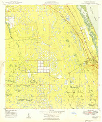
1949 Map of Gomez
USGS Topo · Published 1949About this map
The Gomez Grant and Hanson Grant define the historical land division of this coastal corridor during the late 1940s. The settlement of Hobe Sound serves as a primary hub, situated between the Florida East Coast railway and the saltwater reaches of the Intracoastal Waterway. To the south, the early boundaries of Jupiter State Park preserve a significant portion of the landscape, while inland, the South Fork St Lucie River winds through the western interior. This survey documents a critical period of infrastructure before the heavy mid-century development of the Atlantic coast, marked by an Underground Telephone Line and an Airway Beacon. Local landmarks like the Hobe Sound Ch and Banner Lake provide specific points of interest for genealogists tracing the early footprint of Martin County communities.
Find a feature on this map
18 named features on this map. Tap any name to fly to it.
Don’t see what you’re looking for? This feature index may not catch every label — zoom into the map to look around manually.
Map Details
Editions of this 1949 Gomez Map
2 editions found
Other maps of this area

1948 · Palm City
USGS Topo · 1:24,000

1948 · Rood
USGS Topo · 1:24,000

1948 · St. Lucie Inlet
USGS Topo · 1:24,000

1948 · Gomez
USGS Topo · 1:24,000

1948 · Hobe Sound
USGS Topo · 1:24,000

1948 · Jupiter
USGS Topo · 1:24,000

1949 · Rood
USGS Topo · 1:24,000

1949 · Hobe Sound
USGS Topo · 1:24,000

1950 · St. Lucie Inlet
USGS Topo · 1:24,000

1950 · Palm City
USGS Topo · 1:24,000