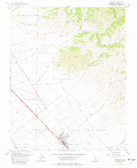
1955 Map of Gonzales
USGS Topo · Published 1981About this map
The agricultural landscape of the Salinas Valley centers on Gonzales, where the Southern Pacific railroad runs parallel to the Salinas River. This mid-century survey illustrates the transition from the flat, irrigated valley floor into the steep terrain of the Gabilan Range. Historic land divisions such as Rincon De La Puente Del Monte and Zanjones remain clearly delineated, reflecting the Spanish and Mexican land grant heritage that organized this part of Monterey County.
Find a feature on this map
29 named features on this map. Tap any name to fly to it.
Don’t see what you’re looking for? This feature index may not catch every label — zoom into the map to look around manually.
Map Details
Editions of this 1955 Gonzales Map
4 editions found
Other maps of this area

1910 · Gonzales
USGS Topo · 1:31,680

1910 · Salinas
USGS Topo · 1:31,680

1910 · Soledad
USGS Topo · 1:31,680

1912 · Salinas
USGS Topo · 1:62,500

1915 · Soledad
USGS Topo · 1:62,500

1920 · Jamesburg
USGS Topo · 1:48,000

1921 · Jamesburg
USGS Topo · 1:62,500

1921 · Gonzales
USGS Topo · 1:62,500

1939 · Jamesburg
USGS Topo · 1:62,500

1940 · Salinas
USGS Topo · 1:62,500