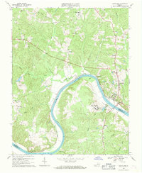
1968 Map of Goochland
USGS Topo · Published 1970About this map
The James River carves a sweeping bend through this central Virginia landscape, acting as a natural boundary between Goochland and Powhatan counties. In the late 1960s, the riverside economy was defined by the Chesapeake and Ohio railroad corridor and institutional landmarks like the State Farm for Women and the State Sch for Boys. The county seat at Goochland and the nearby settlement of Maidens serve as focal points for local commerce, while smaller crossroads like Dogtown and Three Square connect the inland agricultural areas. Genealogy researchers will find several well-placed rural houses of worship, including Byrd Ch and Emmaus Ch, alongside family-named watercourses such as Little Lickinghole Creek and Cheneys Creek. The map also details the Michaux Bridge and several schools, including Goochland Central High School, providing a clear view of the area's social and transit infrastructure before modern expansion.
Find a feature on this map
39 named features on this map. Tap any name to fly to it.
Don’t see what you’re looking for? This feature index may not catch every label — zoom into the map to look around manually.
Map Details
Editions of this 1968 Goochland Map
4 editions found
Other maps of this area

1890 · Goochland
USGS Topo · 1:125,000

1891 · Palmyra
USGS Topo · 1:125,000

1892 · Goochland
USGS Topo · 1:125,000

1895 · Palmyra
USGS Topo · 1:125,000

1897 · Palmyra
USGS Topo · 1:125,000

1943 · Goochland
USGS Topo · 1:31,680

1943 · Fine Creek Mills
USGS Topo · 1:31,680

1943 · Powhatan
USGS Topo · 1:31,680

1943 · Perkinsville
USGS Topo · 1:31,680

1943 · South Anna
USGS Topo · 1:24,000