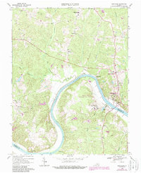
1968 Map of Goochland
USGS Topo · Published 1987About this map
The James River meanders through the heart of the Virginia Piedmont, defining the border between Goochland and Powhatan counties. This landscape in the late 1960s is characterized by its institutional presence and scattered rural settlements. The county seat of Goochland sits on the northern bank, while large state facilities like the Beaumont Learning Center and the Virginia Correctional Center for Women occupy prominent tracts near the river's bend.
Find a feature on this map
44 named features on this map. Tap any name to fly to it.
Don’t see what you’re looking for? This feature index may not catch every label — zoom into the map to look around manually.
Map Details
Editions of this 1968 Goochland Map
4 editions found
Other maps of this area

1890 · Goochland
USGS Topo · 1:125,000

1891 · Palmyra
USGS Topo · 1:125,000

1892 · Goochland
USGS Topo · 1:125,000

1895 · Palmyra
USGS Topo · 1:125,000

1897 · Palmyra
USGS Topo · 1:125,000

1943 · Goochland
USGS Topo · 1:31,680

1943 · Fine Creek Mills
USGS Topo · 1:31,680

1943 · Powhatan
USGS Topo · 1:31,680

1943 · Perkinsville
USGS Topo · 1:31,680

1943 · South Anna
USGS Topo · 1:24,000