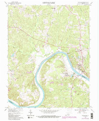
1968 Map of Goochland
USGS Topo · Published 1987About this map
Goochland serves as the focal point of this Piedmont landscape, situated along the northern banks of a sweeping bend in the James River. The late 1960s geography is characterized by a mix of agricultural land and institutional development, notably the Virginia Correctional Center for Women and the Beaumont Learning Center. Transport and connectivity are defined by the CSX rail line and the Michaux Bridge, which links Goochland and Powhatan counties. Educational growth is evident through the presence of the J Sargeant Reynolds Community College and Goochland Central High School. Rural community life is anchored by numerous small settlements and congregations, such as Dogtown, Maidens, and Emmaus Ch, alongside several family-named landmarks like Gregg Lake and Cheneys Creek.
Find a feature on this map
37 named features on this map. Tap any name to fly to it.
Don’t see what you’re looking for? This feature index may not catch every label — zoom into the map to look around manually.
Map Details
Editions of this 1968 Goochland Map
4 editions found
Other maps of this area

1890 · Goochland
USGS Topo · 1:125,000

1891 · Palmyra
USGS Topo · 1:125,000

1892 · Goochland
USGS Topo · 1:125,000

1895 · Palmyra
USGS Topo · 1:125,000

1897 · Palmyra
USGS Topo · 1:125,000

1943 · Goochland
USGS Topo · 1:31,680

1943 · Fine Creek Mills
USGS Topo · 1:31,680

1943 · Powhatan
USGS Topo · 1:31,680

1943 · Perkinsville
USGS Topo · 1:31,680

1943 · South Anna
USGS Topo · 1:24,000