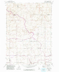
1971 Map of Gooding SE
USGS Topo · Published 1993About this map
The high desert plateau of southern Idaho is defined by its complex irrigation infrastructure, as shown in this detailed study of the area where Gooding Co Jerome Co and Lincoln Co Jerome Co meet. The landscape is dominated by a pervasive Canal system and support structures including a Siphon and multiple Diversion Dam sites. These features underscore the region's total reliance on water engineering to support life and livestock on the arid plains of the Snake River region.
Find a feature on this map
21 named features on this map. Tap any name to fly to it.
Don’t see what you’re looking for? This feature index may not catch every label — zoom into the map to look around manually.
Map Details
Editions of this 1971 Gooding SE Map
2 editions found
Other maps of this area

1950 · Niagara Springs
USGS Topo · 1:24,000

1950 · Jerome
USGS Topo · 1:24,000

1950 · Jerome
USGS Topo · 1:62,500

1955 · Twin Falls
USGS Topo · 1:250,000

1958 · Twin Falls
USGS Topo · 1:250,000

1964 · Falls City
USGS Topo · 1:24,000
1971 · Wendell
USGS Topo · 1:24,000

1971 · Tunupa
USGS Topo · 1:24,000
1971 · Gooding SE
USGS Topo · 1:24,000
1971 · Gooding
USGS Topo · 1:24,000