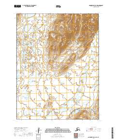
2019 Map of Goodnews Bay A-3 SW
USGS Topo · Published 2019About this map
The Negukthlik River and Ungalikthluk River define the watery character of this corner of southwest Alaska. Located within the Dillingham Census Area, the landscape is marked by the shifting channels and wetlands surrounding these two primary drainage systems. The survey reveals a complex network of seasonal ponds and low-lying drainages, characteristic of the region's hydrography as documented in the early twenty-first century. This topographical record illustrates the intricate natural boundaries between t12s r64w and surrounding survey townships, offering a clear view of the land's relief and river patterns before further environmental shifts. The lack of named settlements emphasizes the isolation and natural state of this interior riverine environment.
Find a feature on this map
6 named features on this map. Tap any name to fly to it.
Don’t see what you’re looking for? This feature index may not catch every label — zoom into the map to look around manually.
Map Details
Editions of this 2019 Goodnews Bay A-3 SW Map
This is the sole edition of this map. No revisions or reprints were ever made.
Other maps of this area

1945 · Nushagak Bay
USGS Topo · 1:250,000

1949 · Nushagak Bay
USGS Topo · 1:250,000

1950 · Nushagak Bay D-6
USGS Topo · 1:63,360

1950 · Hagemeister Island D-1
USGS Topo · 1:63,360

1951 · Goodnews
USGS Topo · 1:250,000

1951 · Hagemeister Island
USGS Topo · 1:250,000

1951 · Nushagak Bay
USGS Topo · 1:250,000

1952 · Hagemeister Island D-1
USGS Topo · 1:63,360

1954 · Goodnews A-4
USGS Topo · 1:63,360

1954 · Goodnews A-3
USGS Topo · 1:63,360