
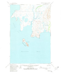
1950 Map of Hagemeister Island D-1
USGS Topo · Published 1974About this map
Summit Island rises within the Walrus Islands State Game Sanctuary, anchored in the waters of Bristol Bay. This 1950s era survey by the U. S. Coast and Geodetic Survey documents a coastline defined by isolation and natural resources. Along the mainland, the Ungalikthluk River winds toward the settlement of Ungalikthluk, while further south, a solitary Cabin sits near the shore, indicating the sparse human footprint in this corner of Alaska. The transition from the alluvial lowlands near Nunavachak Lake to the prominent heights of Vabm Summit 465 illustrates a landscape shaped by water and wind. The survey's focus on inshore detail and topography, including landmarks like Rocky Point and Togiak Bay, captures a coastal environment before significant modern changes, serving as a primary record for those researching the remote maritime history of the region.
Find a feature on this map
12 named features on this map. Tap any name to fly to it.
Don’t see what you’re looking for? This feature index may not catch every label — zoom into the map to look around manually.
Map Details
Editions of this 1950 Hagemeister Island D-1 Map
2 editions found
Other maps of this area

1945 · Nushagak Bay
USGS Topo · 1:250,000

1947 · Hagemeister Island D-2
USGS Topo · 1:63,360
1948 · Hagemeister Island C-2
USGS Topo · 1:63,360

1948 · Hagemeister Island C-1
USGS Topo · 1:63,360

1949 · Nushagak Bay
USGS Topo · 1:250,000

1950 · Nushagak Bay D-6
USGS Topo · 1:63,360

1951 · Goodnews
USGS Topo · 1:250,000

1951 · Hagemeister Island
USGS Topo · 1:250,000

1951 · Nushagak Bay
USGS Topo · 1:250,000

1952 · Hagemeister Island C-1
USGS Topo · 1:63,360