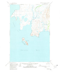
1950 Map of Hagemeister Island D-1
USGS Topo · Published 1981About this map
Summit Island and the surrounding waters of Bristol Bay dominate this coastal survey, where the remote landscape meets the Bering Sea. The shoreline is defined by the mouths of the Ungalikthluk River and Negukthlik River, which drain into the eastern reaches of Togiak Bay. A small settlement at Ungalikthluk and an isolated cabin near the coast reflect the sparse human footprint in this subarctic environment. Much of the southern portion is preserved within the Walrus Islands State Game Sanctuary, indicating the long-standing ecological importance of these rocky outposts. Along the mainland, landmarks like Rocky Point, Sand Beach, and Gravel Beach detail a coastline shaped by intense tidal forces, while Nunavachak Lake sits just inland from the sea.
Find a feature on this map
12 named features on this map. Tap any name to fly to it.
Don’t see what you’re looking for? This feature index may not catch every label — zoom into the map to look around manually.
Map Details
Editions of this 1950 Hagemeister Island D-1 Map
2 editions found
Other maps of this area

1945 · Nushagak Bay
USGS Topo · 1:250,000

1947 · Hagemeister Island D-2
USGS Topo · 1:63,360
1948 · Hagemeister Island C-2
USGS Topo · 1:63,360

1948 · Hagemeister Island C-1
USGS Topo · 1:63,360

1949 · Nushagak Bay
USGS Topo · 1:250,000

1950 · Nushagak Bay D-6
USGS Topo · 1:63,360

1950 · Hagemeister Island D-1
USGS Topo · 1:63,360

1951 · Goodnews
USGS Topo · 1:250,000

1951 · Hagemeister Island
USGS Topo · 1:250,000

1951 · Nushagak Bay
USGS Topo · 1:250,000