
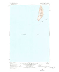
1952 Map of Hagemeister Island C-1
USGS Topo · Published 1954About this map
Crooked Island and the surrounding Walrus Islands rise from the eastern waters of Bristol Bay in this mid-century maritime study. Mapped by the U.S. Coast and Geodetic Survey, the chart provides a clear view of the isolated landforms and coastal depths typical of the Dillingham region in the early 1950s. The topography of Crooked Island is marked by significant elevation, with contour lines defining its steep, elongated ridge. Inset detail captures the rugged profile of Round Island to the southeast, while smaller hazards such as Black Rock I and the Twins emphasize the navigational character of these waters. The survey captures the archipelago before modern shifts in maritime technology, focusing on the natural geography and sounding depths that defined the era's seafaring routes.
Find a feature on this map
6 named features on this map. Tap any name to fly to it.
Don’t see what you’re looking for? This feature index may not catch every label — zoom into the map to look around manually.
Map Details
Editions of this 1952 Hagemeister Island C-1 Map
This is the sole edition of this map. No revisions or reprints were ever made.
Other maps of this area

1945 · Nushagak Bay
USGS Topo · 1:250,000

1947 · Hagemeister Island D-2
USGS Topo · 1:63,360
1948 · Hagemeister Island C-2
USGS Topo · 1:63,360

1948 · Hagemeister Island C-1
USGS Topo · 1:63,360

1949 · Nushagak Bay
USGS Topo · 1:250,000

1950 · Nushagak Bay D-6
USGS Topo · 1:63,360

1950 · Hagemeister Island D-1
USGS Topo · 1:63,360

1951 · Hagemeister Island
USGS Topo · 1:250,000

1951 · Nushagak Bay
USGS Topo · 1:250,000

1952 · Hagemeister Island C-2
USGS Topo · 1:63,360