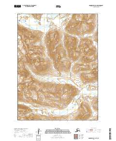
2019 Map of Goodnews Bay D-1 SE
USGS Topo · Published 2019About this map
Nuyakuk Lake feeds into the Nuyakuk River in this remote section of the Dillingham Census Area. The landscape is defined by the sharp transition from the broad waters of the lake in the north to the meandering river system that cuts through the southern terrain. This 2019 survey provides precise topographic detail for a region where water and landform are the primary indicators of place, notably lacking in permanent settlements or man-made infrastructure. The map documents the natural hydrology and elevation of this interior Alaskan wilderness, where the Nuyakuk River serves as the dominant geographic feature for those navigating the area's river-and-lake networks.
Find a feature on this map
8 named features on this map. Tap any name to fly to it.
Don’t see what you’re looking for? This feature index may not catch every label — zoom into the map to look around manually.
Map Details
Editions of this 2019 Goodnews Bay D-1 SE Map
This is the sole edition of this map. No revisions or reprints were ever made.
Other maps of this area

1951 · Dillingham
USGS Topo · 1:250,000

1951 · Goodnews
USGS Topo · 1:250,000

1954 · Dillingham
USGS Topo · 1:250,000

1954 · Dillingham D-8
USGS Topo · 1:63,360

1954 · Dillingham C-8
USGS Topo · 1:63,360

1979 · Goodnews Bay D-1
USGS Topo · 1:63,360

1979 · Goodnews Bay
USGS Topo · 1:250,000

1979 · Goodnews Bay C-1
USGS Topo · 1:63,360
2019 · Dillingham C-8 NW
USGS Topo · 1:25,000
2019 · Dillingham D-8 SW
USGS Topo · 1:25,000