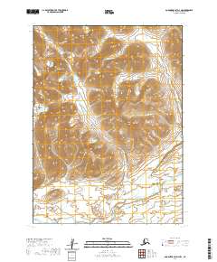
2020 Map of Goodnews Bay D-4 NW
USGS Topo · Published 2020About this map
The Kanektok River dominates the southern reaches of this landscape in the Bethel Census Area, winding through a complex system of low-lying wetlands and braids. To the north, the terrain rises sharply into the high peaks of the Eek Mountains and the prominent Tiokpit Mtn. This environment is defined by its drainage network, with several major tributaries including Amakatatee Cr, Paiyun Cr, and Tsayagtulek Cr carrying meltwater from the highlands down toward the river basin. The map reveals a land structured by its natural topography rather than human infrastructure, showing the intricate contour intervals of the mountains and the shifting hydrology of the valley floor as they appeared in 2020.
Find a feature on this map
10 named features on this map. Tap any name to fly to it.
Don’t see what you’re looking for? This feature index may not catch every label — zoom into the map to look around manually.
Map Details
Editions of this 2020 Goodnews Bay D-4 NW Map
This is the sole edition of this map. No revisions or reprints were ever made.
Other maps of this area

1950 · Bethel
USGS Topo · 1:250,000

1951 · Goodnews
USGS Topo · 1:250,000

1954 · Bethel A-5
USGS Topo · 1:63,360

1954 · Bethel A-4
USGS Topo · 1:63,360

1954 · Goodnews D-4
USGS Topo · 1:63,360

1954 · Goodnews D-5
USGS Topo · 1:63,360

1979 · Goodnews Bay
USGS Topo · 1:250,000

1980 · Bethel
USGS Topo · 1:250,000
2017 · Bethel A-5 SE
USGS Topo · 1:25,000
2017 · Bethel A-4 SE
USGS Topo · 1:25,000