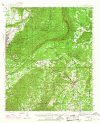
1944 Map of Goodwater
USGS Topo · Published 1967About this map
The Talladega Mountains dominate this mid-century landscape, as the Talladega National Forest spans across much of the terrain between Sylacauga and Goodwater. The survey captures a rural Alabama economy reliant on the corridors of the Louisville and Nashville and Central of Georgia railroads. Local life centers on established crossroads and rural landmarks such as Hollins, Stewartville, and Hanover. Genealogists will find significant detail in the placement of community institutions like Marvin Chapel, Liberty Hill Ch, and the Mt Pleasant Cem. The transition from industrial rail centers to the high ridges of Rocky Mountain and Locust Mtn illustrates the area's physical isolation and the strategic importance of passes like Heards Gap and Bulls Gap for regional travel.
Find a feature on this map
57 named features on this map. Tap any name to fly to it.
Don’t see what you’re looking for? This feature index may not catch every label — zoom into the map to look around manually.
Map Details
Editions of this 1944 Goodwater Map
3 editions found
Other maps of this area

1890 · Talladega
USGS Topo · 1:125,000

1891 · Ashland
USGS Topo · 1:125,000

1892 · Talladega
USGS Topo · 1:125,000

1901 · Wetumpka
USGS Topo · 1:125,000

1903 · Wetumpka
USGS Topo · 1:125,000

1906 · Dadeville
USGS Topo · 1:125,000

1915 · Gantts Quarry
USGS Topo · 1:48,000

1917 · Gantts Quarry
USGS Topo · 1:62,500

1943 · Talladega
USGS Topo · 1:62,500

1944 · Goodwater
USGS Topo · 1:62,500