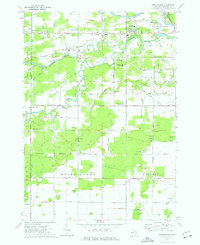
1973 Map of Gordonville
USGS Topo · Published 1976About this map
The Chippewa River and Pine River converge in this mid-1970s survey of the landscape south of Midland. The area's industrial character is defined by the numerous Brine Wells scattered across the townships of Homer, Mount Haley, and Ingersoll, reflecting the region's history of chemical and mineral extraction. This map captures the rural-to-suburban transition, documented through clusters of family and community landmarks like Dice Corners, the Townhall in Mount Haley, and several educational sites including Bullock Creek High Sch. Local genealogy is well-represented by several burial grounds, including Wayne Cem and Poseyville Cem, alongside several country churches. The northeastern corner shows the edge of Midland's city infrastructure, featuring Emerson Park, the Golf Course, and the Chesapeake and Ohio railroad corridor tracking alongside the Tittabawassee River.
Find a feature on this map
58 named features on this map. Tap any name to fly to it.
Don’t see what you’re looking for? This feature index may not catch every label — zoom into the map to look around manually.
Map Details
Editions of this 1973 Gordonville Map
This is the sole edition of this map. No revisions or reprints were ever made.
Other maps of this area

1917 · St. Charles
USGS Topo · 1:62,500

1934 · Sanford
USGS Topo · 1:62,500

1934 · Merrill
USGS Topo · 1:62,500

1936 · Sanford
USGS Topo · 1:62,500

1937 · Merrill
USGS Topo · 1:62,500

1943 · St. Charles
USGS Topo · 1:62,500

1954 · Midland
USGS Topo · 1:250,000

1958 · Midland
USGS Topo · 1:250,000

1959 · Midland
USGS Topo · 1:250,000

1962 · Midland South
USGS Topo · 1:24,000