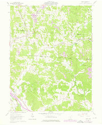
1961 Map of Gore
USGS Topo · Published 1976About this map
Monday Creek and its many tributaries, such as Little Monday Creek and Monkey Run, carve through the complex topography of the Wayne National Forest at the border of Perry and Hocking Counties. This landscape is defined by the legacy of early industrial extraction, shown through numerous Strip Mine sites and the historic Bessie Furnace near Oreville. The network of the Chesapeake and Ohio railroad connects small settlements like Gore and Greendale, providing a glimpse into the coal and clay economy of the mid-20th century.
Find a feature on this map
46 named features on this map. Tap any name to fly to it.
Don’t see what you’re looking for? This feature index may not catch every label — zoom into the map to look around manually.
Map Details
Editions of this 1961 Gore Map
Other maps of this area

1903 · Athens
USGS Topo · 1:62,500

1904 · Zaleski
USGS Topo · 1:62,500

1905 · Athens
USGS Topo · 1:62,500

1907 · Zaleski
USGS Topo · 1:62,500

1907 · Logan
USGS Topo · 1:62,500

1909 · Logan
USGS Topo · 1:62,500

1911 · New Lexington
USGS Topo · 1:62,500

1947 · Columbus
USGS Topo · 1:250,000

1961 · Columbus
USGS Topo · 1:250,000

1961 · Nelsonville
USGS Topo · 1:24,000