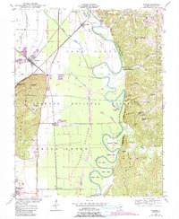
1947 Map of Gorham
USGS Topo · Published 1990About this map
The Big Muddy River meanders through the heart of this landscape, carving a series of dramatic loops including Horseshoe Bend, Mill Bend, and Cripps Bend. The terrain is defined by the sharp contrast between the flat Oakwood Bottoms and the prominent elevations of Fountain Bluff and Walker Hill. This 1947 survey shows the intersection of the Illinois Central Railroad and the Missouri Pacific Railroad at Gorham, a vital rail junction of the era. To the east, the Shawnee National Forest encompasses the ridge-and-hollow topography where the Hickory Ridge Lookout Tower once stood. Small communities like Sand Ridge and Grand Tower anchor the river economy, while rural infrastructure is represented by the Hickory Ridge School and several family burial grounds, such as Hudson Cem and Henson Cem.
Find a feature on this map
58 named features on this map. Tap any name to fly to it.
Don’t see what you’re looking for? This feature index may not catch every label — zoom into the map to look around manually.
Map Details
Editions of this 1947 Gorham Map
4 editions found
Other maps of this area

1910 · Murphysboro
USGS Topo · 1:62,500

1916 · Campbell Hill
USGS Topo · 1:62,500

1918 · Altenburg
USGS Topo · 1:62,500

1918 · Campbell Hill
USGS Topo · 1:62,500

1924 · Alto Pass
USGS Topo · 1:62,500

1925 · Altenburg
USGS Topo · 1:62,500

1938 · Murphysboro
USGS Topo · 1:62,500

1947 · Alto Pass
USGS Topo · 1:62,500

1947 · Gorham
USGS Topo · 1:24,000
1947 · Wolf Lake
USGS Topo · 1:24,000