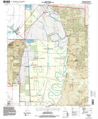
1994 Map of Gorham
USGS Topo · Published 1996About this map
Fountain Bluff rises sharply from the alluvial floor of the Big Muddy River, dominating a landscape defined by significant drainage and timber management. This 1990s revision reveals the intricate waterway system within the Shawnee National Forest, including the numerous oxbow bends like Horseshoe Bend and Cripps Bend along the river's winding course. The lowlands are marked by extensive levee systems and ditches such as Hay Glade Ditch, protecting the Grand Tower Bottoms and agricultural tracts near Sand Ridge.
Find a feature on this map
55 named features on this map. Tap any name to fly to it.
Don’t see what you’re looking for? This feature index may not catch every label — zoom into the map to look around manually.
Map Details
Editions of this 1994 Gorham Map
2 editions found
Other maps of this area

1910 · Murphysboro
USGS Topo · 1:62,500

1916 · Campbell Hill
USGS Topo · 1:62,500

1918 · Altenburg
USGS Topo · 1:62,500

1918 · Campbell Hill
USGS Topo · 1:62,500

1924 · Alto Pass
USGS Topo · 1:62,500

1925 · Altenburg
USGS Topo · 1:62,500

1938 · Murphysboro
USGS Topo · 1:62,500

1947 · Alto Pass
USGS Topo · 1:62,500

1947 · Gorham
USGS Topo · 1:24,000
1947 · Wolf Lake
USGS Topo · 1:24,000