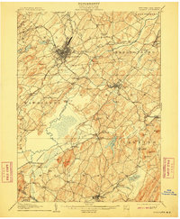
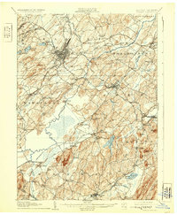
1908 Map of Goshen
USGS Topo · Published 1910About this map
Middletown serves as a major rail hub at the start of the twentieth century, where the Erie R R and New York Ontario and Western RR intersect with the Middletown and Unionville Electric RR. The landscape to the south and east is defined by the massive drainage project of the Commissioners Ditch and the fertile bottomlands of the Wallkill River valley. This era reveals a transition from dense village centers like Goshen to rural farmsteads and family-named hamlets such as Mapes Corners and Michigan Corners. To the south, the peaks of Mt Adam and Mt Eve rise above the wetlands of the Quaker Creek (North Branch), providing a stark topographical contrast to the valley floor. Researchers can trace the extensive network of dairy-country branch lines, including the Erie R R (Pine Island Br) reaching into the rich mucklands near Florida.
Find a feature on this map
112 named features on this map. Tap any name to fly to it.
Don’t see what you’re looking for? This feature index may not catch every label — zoom into the map to look around manually.
Map Details
Editions of this 1908 Goshen Map
6 editions found

Other maps of this area

1888 · Franklin
USGS Topo · 1:62,500

1891 · Greenwood Lake
USGS Topo · 1:62,500

1891 · Ramapo
USGS Topo · 1:62,500

1893 · Greenwood Lake
USGS Topo · 1:62,500

1893 · Ramapo
USGS Topo · 1:62,500

1894 · Franklin
USGS Topo · 1:62,500

1897 · Franklin
USGS Topo · 1:62,500

1902 · Schunemunk
USGS Topo · 1:62,500

1903 · Newburg
USGS Topo · 1:62,500

1903 · Franklin Furnace
USGS Topo · 1:62,500