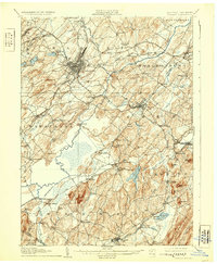
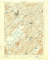
1908 Map of Goshen
USGS Topo · Published 1931About this map
The Wallkill River and a complex web of railroads dominate this early twentieth-century landscape in Orange County. Hubs like Middletown and Goshen serve as central nodes for several competing rail lines, including the Erie R R and the New York Ontario and Western. The terrain is defined by dramatic rises such as the Shawangunk Mts and isolated peaks like Sugarloaf Mtn, while the lowlands are managed through significant drainage projects like the Commissioners Ditch.
Find a feature on this map
104 named features on this map. Tap any name to fly to it.
Don’t see what you’re looking for? This feature index may not catch every label — zoom into the map to look around manually.
Map Details
Editions of this 1908 Goshen Map
6 editions found

Other maps of this area

1888 · Franklin
USGS Topo · 1:62,500

1891 · Greenwood Lake
USGS Topo · 1:62,500

1891 · Ramapo
USGS Topo · 1:62,500

1893 · Greenwood Lake
USGS Topo · 1:62,500

1893 · Ramapo
USGS Topo · 1:62,500

1894 · Franklin
USGS Topo · 1:62,500

1897 · Franklin
USGS Topo · 1:62,500

1902 · Schunemunk
USGS Topo · 1:62,500

1903 · Newburg
USGS Topo · 1:62,500

1903 · Franklin Furnace
USGS Topo · 1:62,500