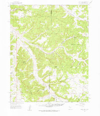
1959 Map of Gould Pass
USGS Topo · Published 1962About this map
Largo Field and the surrounding high desert mesas define this region at the intersection of San Juan and Rio Arriba counties. The 1959 survey reveals a landscape heavily marked by energy exploration within the Largo San Juan Basin, where numerous gas wells and pipelines traverse the network of deep drainages. Topography is the dominant feature, with massive landforms like Manzanares Mesa and Delgadito Mesa rising above a labyrinth of named canyons including Manzanares Canyon, Jesus Canyon, and Blanco Canyon.
Find a feature on this map
32 named features on this map. Tap any name to fly to it.
Don’t see what you’re looking for? This feature index may not catch every label — zoom into the map to look around manually.
Map Details
Editions of this 1959 Gould Pass Map
2 editions found
Other maps of this area

1889 · Largo
USGS Topo · 1:250,000

1895 · Largo
USGS Topo · 1:250,000

1954 · Pine River
USGS Topo · 1:24,000

1954 · Gomez Ranch
USGS Topo · 1:24,000

1954 · Aztec
USGS Topo · 1:250,000

1958 · Aztec
USGS Topo · 1:250,000

1959 · Gould Pass
USGS Topo · 1:62,500

1959 · Aztec
USGS Topo · 1:62,500

1959 · Navajo Dam
USGS Topo · 1:62,500

1959 · Nageezi
USGS Topo · 1:62,500