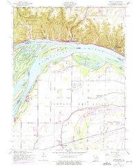
1954 Map of Grafton
USGS Topo · Published 1975About this map
The confluence of the Mississippi and Illinois rivers dominates this landscape, where the bluffs of Pere Marquette State Park overlook a complex network of islands and chutes. The river-centered economy is evident in the Illinois-Missouri Ferry connecting the rugged Illinois side at Grafton with the low, fertile plains of Portage Des Sioux. The map reveals a clear geological divide: the northern bluffs are carved by numerous named hollows like Distillery Hollow and Baby Hollow, while the southern floodplain is defined by drainage features such as Marais Temps Clair and Luesseville Lake. Land use patterns show a distinct shift from the upland Quarry and state park lands to the structured agricultural grids around Orchard Farm, where rural infrastructure including the Lake View Sch and Smartt Airfield served the mid-century Missouri bottomlands.
Find a feature on this map
52 named features on this map. Tap any name to fly to it.
Don’t see what you’re looking for? This feature index may not catch every label — zoom into the map to look around manually.
Map Details
Editions of this 1954 Grafton Map
4 editions found
Other maps of this area

1903 · O'Fallon
USGS Topo · 1:125,000

1924 · Robertson
USGS Topo · 1:24,000

1927 · St. Charles
USGS Topo · 1:62,500

1930 · Hardin
USGS Topo · 1:62,500

1930 · Jerseyville
USGS Topo · 1:62,500

1931 · Brussels
USGS Topo · 1:62,500

1933 · Jerseyville
USGS Topo · 1:62,500

1933 · Saint Charles
USGS Topo · 1:62,500

1934 · Hardin
USGS Topo · 1:62,500

1935 · Florissant
USGS Topo · 1:24,000