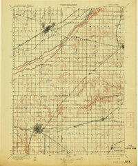
1898 Map of Grand Island
USGS Topo · Published 1914About this map
The Platte River and its intricate network of braids—including the North Channel Platte River, Middle Channel Platte River, and South Channel Platte River—dominate this late 19th-century landscape. This is a region defined by the convergence of major rail lines and early river crossings like the Hamilton Bridge and Grand Island Bridge. Large hubs like Grand Island and Hastings appear at their early stages of growth, serving as vital junctions for the Union Pacific R.R. and the sprawling Burlington and Missouri River R.R. networks.
Find a feature on this map
74 named features on this map. Tap any name to fly to it.
Don’t see what you’re looking for? This feature index may not catch every label — zoom into the map to look around manually.
Map Details
Editions of this 1898 Grand Island Map
4 editions found

Other maps of this area

1892 · Grand Island
USGS Topo · 1:62,500

1894 · Kenesaw
USGS Topo · 1:62,500

1895 · Grand Island
USGS Topo · 1:62,500

1895 · Wood River
USGS Topo · 1:62,500

1896 · Wood River
USGS Topo · 1:125,000

1896 · Stromsburg
USGS Topo · 1:125,000

1897 · Red Cloud
USGS Topo · 1:125,000

1898 · York
USGS Topo · 1:125,000

1898 · Superior
USGS Topo · 1:125,000

1898 · Hebron
USGS Topo · 1:125,000