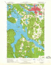
1953 Map of Grand Rapids
USGS Topo · Published 1968About this map
Grand Rapids serves as the focal point of this mid-century survey, situated at the confluence of the Mississippi River and the expansive Pokegama Lake. The town's industrial and civic infrastructure is clearly defined, featuring the Great Northern railroad corridor, the courthouse, and the Paper Mill Reservoir. The landscape is dominated by the intricate shoreline of the lake, with its numerous indentations like Sugar Bay and the elongated Wendigo Arm and Sherry Arm reaching to the south. Local landmarks including the Municipal Airport, Calvary Cem, and Murphy Sch provide specific points of interest for genealogical research and community history. Further exploration reveals evidence of the region's extractive economy at the Tioga Mine and various Gravel Pits, while islands such as Wilder Island and Drumbeater Island break the open water.
Find a feature on this map
49 named features on this map. Tap any name to fly to it.
Don’t see what you’re looking for? This feature index may not catch every label — zoom into the map to look around manually.
Map Details
Editions of this 1953 Grand Rapids Map
4 editions found
Other maps of this area

1920 · Trout Lake
USGS Topo · 1:62,500

1952 · Bovey
USGS Topo · 1:24,000

1953 · Cohasset East
USGS Topo · 1:24,000

1953 · Siseebakwet Lake
USGS Topo · 1:24,000

1953 · Cohasset West
USGS Topo · 1:24,000

1953 · Grand Rapids
USGS Topo · 1:24,000

1954 · Hibbing
USGS Topo · 1:250,000

1957 · Hibbing
USGS Topo · 1:250,000

1958 · Hibbing
USGS Topo · 1:250,000

1964 · Hibbing
USGS Topo · 1:250,000
Featured Places
- Grand Rapids, MN
- Cohasset, MN
- La Prairie, MN
- Wagon Wheel Mobile Home Park, Grand Rapids
- Acheson Mobile Home Village, La Prairie