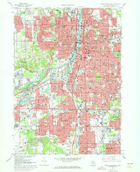
1967 Map of Grand Rapids West
USGS Topo · Published 1973About this map
The Grand River carves a central path through this mid-century portrait of Michigan's industrial heart, revealing the dense urban development of Grand Rapids and its emerging neighbors. This period shows a landscape defined by significant institutional growth, from the sprawling Kent Industrial Center in the south to the concentration of medical and educational facilities like St Marys Hospital and Junior College. The map is particularly valuable for its record of civic and religious geography, preserving the locations of numerous parish schools such as St Adalberts Sch and St Francis Xavier Sch. Along the riverbanks, recreational and cultural sites like John Ball Park and the ancient Hopewell Indian Mounds Park contrast with the heavy rail infrastructure of the Chesapeake and Ohio and Penn Central lines that fueled the local economy.
Find a feature on this map
168 named features on this map. Tap any name to fly to it.
Don’t see what you’re looking for? This feature index may not catch every label — zoom into the map to look around manually.
Map Details
Editions of this 1967 Grand Rapids West Map
4 editions found
Other maps of this area

1914 · Grand Rapids
USGS Topo · 1:62,500

1918 · Cedar Springs
USGS Topo · 1:62,500

1943 · Cedar Springs
USGS Topo · 1:62,500

1943 · Grand Rapids
USGS Topo · 1:62,500

1945 · Ravenna
USGS Topo · 1:62,500

1954 · Midland
USGS Topo · 1:250,000

1958 · Midland
USGS Topo · 1:250,000

1958 · Grandville
USGS Topo · 1:62,500

1958 · Grandville
USGS Topo · 1:24,000

1958 · Grand Rapids
USGS Topo · 1:250,000