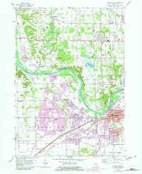
1958 Map of Grandville
USGS Topo · Published 1982About this map
The Grand River winds through this 1958 landscape, marking the boundary between Ottawa and Kent counties as it flows past the growing suburban reaches of Jenison and Grandville. The area shows a heavy reliance on the Chesapeake and Ohio railroad corridor, which parallels Chicago Drive through the industrial and residential heart of the region. Local community life is anchored by numerous institutions, including the Bursley Sch, Zion Ch, and the Drive-in Theater near Standale.
Find a feature on this map
56 named features on this map. Tap any name to fly to it.
Don’t see what you’re looking for? This feature index may not catch every label — zoom into the map to look around manually.
Map Details
Editions of this 1958 Grandville Map
Other maps of this area

1914 · Grand Rapids
USGS Topo · 1:62,500

1918 · Cedar Springs
USGS Topo · 1:62,500

1943 · Cedar Springs
USGS Topo · 1:62,500

1943 · Grand Rapids
USGS Topo · 1:62,500

1945 · Ravenna
USGS Topo · 1:62,500

1954 · Midland
USGS Topo · 1:250,000

1958 · Midland
USGS Topo · 1:250,000

1958 · Allendale
USGS Topo · 1:24,000

1958 · Grandville
USGS Topo · 1:62,500

1958 · Grandville
USGS Topo · 1:24,000