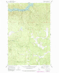
1969 Map of Grangemont
USGS Topo · Published 1985About this map
Grangemont serves as the primary focal point of this North Central Idaho landscape, documented just as the region’s topography was being reshaped by major water management projects. To the north, the North Fork Clearwater River gives way to the newly formed Dworshak Reservoir, a massive impoundment at an elevation of 1600 feet. The terrain is defined by prominent high points such as Angel Butte and Huckleberry Butte, with a dense network of drainages including Whiskey Creek, Crooked Creek, and Canyon Creek cutting through the timbered uplands. Genealogists and local historians will find the Marsh Cem near the center of the sheet, providing a vital point of reference for families tied to this remote part of Clearwater County. The map also traces a Jeep Trail and several secondary roads that provided access to the high ridges and creek bottoms during the late 1960s.
Find a feature on this map
16 named features on this map. Tap any name to fly to it.
Don’t see what you’re looking for? This feature index may not catch every label — zoom into the map to look around manually.
Map Details
Editions of this 1969 Grangemont Map
3 editions found
Other maps of this area

1923 · Washington Creek
USGS Topo · 1:125,000

1924 · Kamiah
USGS Topo · 1:125,000

1924 · Weippe
USGS Topo · 1:125,000

1938 · Headquarters
USGS Topo · 1:48,000

1944 · Headquarters
USGS Topo · 1:62,500

1955 · Pullman
USGS Topo · 1:250,000

1956 · Hamilton
USGS Topo · 1:250,000

1958 · Pullman
USGS Topo · 1:250,000

1959 · Hamilton
USGS Topo · 1:250,000

1960 · Hamilton
USGS Topo · 1:250,000