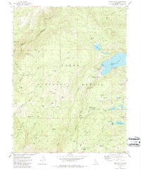
1982 Map of Graniteville
USGS Topo · Published 1986About this map
Graniteville stands as a primary focal point in this high-elevation portion of the Tahoe National Forest, where the history of gold extraction is etched into the landscape. The map reveals an intricate network of industrial sites from a previous era, including the Old Condon Mill and the Marsh Mill, alongside numerous extractive operations like the Birchville Mine, Azalea Mine, and Baltic Mine. The geography is defined by the steep drainage of the Middle Fork Yuba River and the significant basin of Bowman Lake. Local history and genealogy are supported by the presence of a Cem near the main settlement and the identified location of Gaston, indicating where community life once centered. The land is marked by distinct features like the Windy Point Cliffs and a web of 4WD trails that follow the old routes through Poorman Creek and across Gaston Ridge.
Find a feature on this map
71 named features on this map. Tap any name to fly to it.
Don’t see what you’re looking for? This feature index may not catch every label — zoom into the map to look around manually.
Map Details
Editions of this 1982 Graniteville Map
4 editions found
Other maps of this area

1891 · Downieville
USGS Topo · 1:125,000

1891 · Colfax
USGS Topo · 1:125,000

1892 · Colfax
USGS Topo · 1:125,000

1893 · Downieville
USGS Topo · 1:125,000

1894 · Colfax
USGS Topo · 1:125,000

1895 · Downieville
USGS Topo · 1:125,000

1896 · Downieville
USGS Topo · 1:125,000

1897 · Downieville
USGS Topo · 1:125,000

1898 · Colfax
USGS Topo · 1:125,000

1900 · Colfax
USGS Topo · 1:125,000