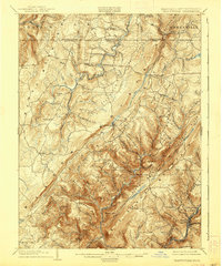
1904 Map of Grantsville
USGS Topo · Published 1938About this map
The Casselman River and the Savage River carve deep valleys through the high country of Garrett County at the turn of the century. This 1904 edition, based on an 1898 survey, captures the region's transport network before mid-century modernization, centered on the historic National Road which passes through Grantsville. To the south, the timber and mining economies are visible through specialized rail lines like the Jennings Brothers RR and the B and O RR, which serves industrial outposts like Barton and Moscow Mills. The landscape is a complex system of ridges and hollows, including Maynardier Ridge and Peapatch Ridge, where small mountain settlements like New Germany and Bittinger are established near the numerous runs and licks that feed the larger river basins.
Find a feature on this map
91 named features on this map. Tap any name to fly to it.
Don’t see what you’re looking for? This feature index may not catch every label — zoom into the map to look around manually.
Map Details
Editions of this 1904 Grantsville Map
5 editions found
Other maps of this area

1891 · Romney
USGS Topo · 1:125,000

1895 · Piedmont
USGS Topo · 1:125,000

1898 · Frostburg
USGS Topo · 1:62,500

1899 · Grantsville
USGS Topo · 1:62,500

1899 · Oakland
USGS Topo · 1:62,500

1900 · Accident
USGS Topo · 1:62,500

1900 · Oakland
USGS Topo · 1:62,500

1901 · Frostburg
USGS Topo · 1:62,500

1904 · Grantsville
USGS Topo · 1:62,500

1908 · Frostburg
USGS Topo · 1:62,500