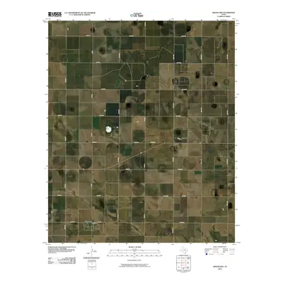
2010 Map of Grassland
USGS Topo · Published 2010About this map
Grassland serves as the central hub of this agricultural landscape in Lynn County, defined by a rigid rectilinear grid of section roads and farm-to-market routes. The map illustrates a highly organized rural infrastructure, where transportation is dominated by a systematic labeling of county roads including Co Rd FF, Co Rd HH, and Co Rd II. These north-south arteries intersect with east-west paths like Co Rd 22 and Co Rd 24, facilitating movement between the isolated farmsteads and small depressions that dot the high plains. Larger regional connections are maintained through Fm 212 and Fm 1313, which anchor the small settlement of Grassland within the broader West Texas geographic system. The sparse distribution of buildings reflects the large-scale ranching and farming operations characteristic of the region in the early 21st century.
Find a feature on this map
25 named features on this map. Tap any name to fly to it.
Don’t see what you’re looking for? This feature index may not catch every label — zoom into the map to look around manually.
Map Details
Editions of this 2010 Grassland Map
This is the sole edition of this map. No revisions or reprints were ever made.
Other maps of this area

1954 · Lubbock
USGS Topo · 1:250,000

1965 · Southland
USGS Topo · 1:24,000

1965 · Wilson
USGS Topo · 1:24,000

1968 · South Dokegood Creek
USGS Topo · 1:24,000

1969 · Grassland SE
USGS Topo · 1:24,000

1969 · Post West
USGS Topo · 1:24,000
1969 · Middle Creek
USGS Topo · 1:24,000

1970 · New Lynn
USGS Topo · 1:24,000
1970 · Draw
USGS Topo · 1:24,000

1970 · Grassland
USGS Topo · 1:24,000