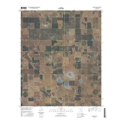
2016 Map of Grassland
USGS Topo · Published 2016About this map
Grassland serves as the primary focal point of this 2016 survey, situated in the high plains of West Texas along the jurisdictional boundary of Lynn Co and Garza Co. The landscape is defined by a rigid orthogonal grid of county roads, such as Co Rd 18 and Co Rd 280, which partition the territory into large agricultural blocks. This geometric layout reflects the systematic land divisions common to the region's farming and ranching heritage. Several significant thoroughfares, including Fm 212 and Fm 1313, provide the necessary connectivity between the local community and the surrounding rural infrastructure. The terrain is marked by numerous depressions and wetlands typical of the Llano Estacado, which break the otherwise structured road network and indicate the natural drainage patterns of the area.
Find a feature on this map
26 named features on this map. Tap any name to fly to it.
Don’t see what you’re looking for? This feature index may not catch every label — zoom into the map to look around manually.
Map Details
Editions of this 2016 Grassland Map
This is the sole edition of this map. No revisions or reprints were ever made.
Other maps of this area

1954 · Lubbock
USGS Topo · 1:250,000
1965 · Southland
USGS Topo · 1:24,000
1965 · Wilson
USGS Topo · 1:24,000
1968 · South Dokegood Creek
USGS Topo · 1:24,000
1969 · Grassland SE
USGS Topo · 1:24,000
1969 · Post West
USGS Topo · 1:24,000
1969 · Middle Creek
USGS Topo · 1:24,000
1970 · New Lynn
USGS Topo · 1:24,000
1970 · Draw
USGS Topo · 1:24,000
1970 · Grassland
USGS Topo · 1:24,000