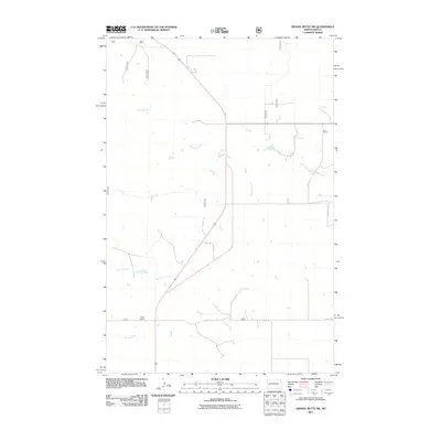
2011 Map of Grassy Butte SW
USGS Topo · Published 2011About this map
Beicegel Creek meanders through the heart of this North Dakota landscape, joined by the headwaters of the Little Knife River and North Creek. The terrain is defined by a network of rural routes and farm-to-market roads, including 85, 200, and 10th St SW. The Haag Ranch stands as a primary point of human settlement in this quiet corner of McKenzie County. This survey reflects the expansive ranching and agricultural nature of the region, where water sources like Spring Creek are essential landmarks in a topography otherwise dictated by the grid of local roads and the occasional stretch of 125th Ave.
Find a feature on this map
20 named features on this map. Tap any name to fly to it.
Don’t see what you’re looking for? This feature index may not catch every label — zoom into the map to look around manually.
Map Details
Editions of this 2011 Grassy Butte SW Map
This is the sole edition of this map. No revisions or reprints were ever made.
Other maps of this area

1953 · Watford City
USGS Topo · 1:250,000

1957 · Watford City
USGS Topo · 1:250,000

1963 · Fairfield
USGS Topo · 1:24,000

1963 · Gorham
USGS Topo · 1:24,000

1963 · Hungry Man Butte
USGS Topo · 1:24,000

1967 · Watford City
USGS Topo · 1:250,000

1974 · Grassy Butte SW
USGS Topo · 1:24,000

1974 · Petes Creek
USGS Topo · 1:24,000

1974 · Buckskin Butte
USGS Topo · 1:24,000
1974 · Scairt Woman Draw
USGS Topo · 1:24,000