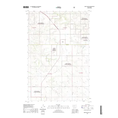
2020 Map of Grassy Butte SW
USGS Topo · Published 2020About this map
The Little Missouri National Grassland dominates this section of the western North Dakota badlands, spanning the border between McKenzie Co and Billings Co. The landscape is defined by the drainage patterns of Beicegel Cr and the Little Knife River, which cut through the high plains terrain. A notable cultural landmark is the Grassy Butte Seventh Day Adventist Church Cem, located in the northeastern quadrant of the sheet. The map reveals a sparse network of section-line roads, such as 125th Ave SW and 10th St, which serve the remote ranching and grazing land. The intricate contour lines illustrate the complex topography typical of the Missouri Plateau, where intermittent streams like N Cr and Spring Cr have carved deep coulees into the surrounding grasslands.
Find a feature on this map
19 named features on this map. Tap any name to fly to it.
Don’t see what you’re looking for? This feature index may not catch every label — zoom into the map to look around manually.
Map Details
Editions of this 2020 Grassy Butte SW Map
This is the sole edition of this map. No revisions or reprints were ever made.
Other maps of this area

1953 · Watford City
USGS Topo · 1:250,000

1957 · Watford City
USGS Topo · 1:250,000

1963 · Fairfield
USGS Topo · 1:24,000

1963 · Gorham
USGS Topo · 1:24,000

1963 · Hungry Man Butte
USGS Topo · 1:24,000

1967 · Watford City
USGS Topo · 1:250,000

1974 · Grassy Butte SW
USGS Topo · 1:24,000

1974 · Petes Creek
USGS Topo · 1:24,000

1974 · Buckskin Butte
USGS Topo · 1:24,000
1974 · Scairt Woman Draw
USGS Topo · 1:24,000