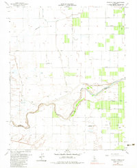
1963 Map of Gravelly Ford
USGS Topo · Published 1983About this map
The San Joaquin River snakes through this Central Valley landscape, defining the boundary between Madera and Fresno counties. During the early 1960s, this region was characterized by an intricate network of irrigation and water management, evidenced by the Herndon Canal and the clearly marked Gravelly Ford Canal (Abandoned). The presence of Gravelly Ford Ranch near the riverbank suggests the long-standing agricultural importance of this riparian corridor.
Find a feature on this map
25 named features on this map. Tap any name to fly to it.
Don’t see what you’re looking for? This feature index may not catch every label — zoom into the map to look around manually.
Map Details
Editions of this 1963 Gravelly Ford Map
3 editions found
Other maps of this area

1920 · Bonita Ranch
USGS Topo · 1:31,680

1921 · Mendota
USGS Topo · 1:31,680

1921 · Bonita Ranch
USGS Topo · 1:31,680

1922 · Kentucky Well
USGS Topo · 1:31,680

1922 · Madera
USGS Topo · 1:31,680

1923 · Biola
USGS Topo · 1:31,680

1924 · Jamesan
USGS Topo · 1:31,680

1924 · Tranquillity
USGS Topo · 1:31,680

1924 · Gravelly Ford
USGS Topo · 1:31,680

1924 · Mendota
USGS Topo · 1:31,680