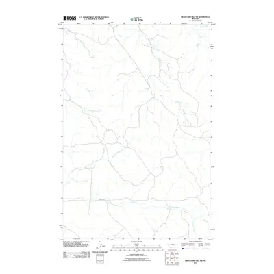
2011 Map of Graveyard Hill SW
USGS Topo · Published 2011About this map
The intricate drainage network of Ash Creek and its many tributaries, including North Fork Ash Creek and Little Fork Ash Creek, dominates this portion of Prairie County. The landscape is characterized by a high density of seasonal watercourses and gullies, with Huey Creek and South Fork Huey Creek carving through the western terrain. Evidence of the region's rural infrastructure is visible through specialized thoroughfares such as Oilwell Rd and Oilfield Rd, reflecting the area's connection to local energy resources. To the northeast, the presence of the Labelle Ditch near Cedar Creek signifies historic water management and agricultural efforts in an otherwise arid environment. This 2011 survey by the U.S. Geological Survey provides a detailed look at the topographic character of this remote landscape as it appeared in the early 21st century.
Find a feature on this map
12 named features on this map. Tap any name to fly to it.
Don’t see what you’re looking for? This feature index may not catch every label — zoom into the map to look around manually.
Map Details
Editions of this 2011 Graveyard Hill SW Map
This is the sole edition of this map. No revisions or reprints were ever made.
Other maps of this area

1953 · Miles City
USGS Topo · 1:250,000

1957 · Miles City
USGS Topo · 1:250,000

1958 · Miles City
USGS Topo · 1:250,000

1967 · Hoyt
USGS Topo · 1:24,000
1967 · Upper Magpie Reservoir
USGS Topo · 1:24,000

1967 · Twin Forks Reservoir
USGS Topo · 1:24,000

1981 · Mildred NE
USGS Topo · 1:24,000

1981 · Dorothy Draw
USGS Topo · 1:24,000

1981 · Ayer Spring NE
USGS Topo · 1:24,000

1981 · Wibaux
USGS Topo · 1:100,000