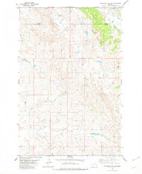
1982 Map of Graveyard Hill SW
USGS Topo · Published 1982About this map
The North Pine Oil Field dominates the northeastern landscape of this eastern Montana survey, showing a network of energy infrastructure alongside traditional ranching terrain. This 1982 edition captures a high-plains environment where industry and nature coexist, marked by numerous Oil Wells and a pipeline traversing the drainage of Cedar Creek. The border between Dawson Co and Prairie Co cuts through the northern section, tracing a line through rolling topography defined by seasonal watercourses. Natural drainage patterns are dictated by the North Fork Ash Creek and the main channel of Ash Creek, which carve through the southern half of the quadrangle. Sparse human settlements are represented by isolated structures like a Cabin and a Substa, reflecting the low-density land use typical of the region during the early 1980s. Further north, the Labelle Ditch and Huey Creek provide additional topographical detail for researchers studying Montana's water rights and petroleum history.
Find a feature on this map
10 named features on this map. Tap any name to fly to it.
Don’t see what you’re looking for? This feature index may not catch every label — zoom into the map to look around manually.
Map Details
Editions of this 1982 Graveyard Hill SW Map
This is the sole edition of this map. No revisions or reprints were ever made.
Other maps of this area

1953 · Miles City
USGS Topo · 1:250,000

1957 · Miles City
USGS Topo · 1:250,000

1958 · Miles City
USGS Topo · 1:250,000

1967 · Hoyt
USGS Topo · 1:24,000
1967 · Upper Magpie Reservoir
USGS Topo · 1:24,000

1967 · Twin Forks Reservoir
USGS Topo · 1:24,000

1981 · Mildred NE
USGS Topo · 1:24,000

1981 · Dorothy Draw
USGS Topo · 1:24,000

1981 · Ayer Spring NE
USGS Topo · 1:24,000

1981 · Wibaux
USGS Topo · 1:100,000