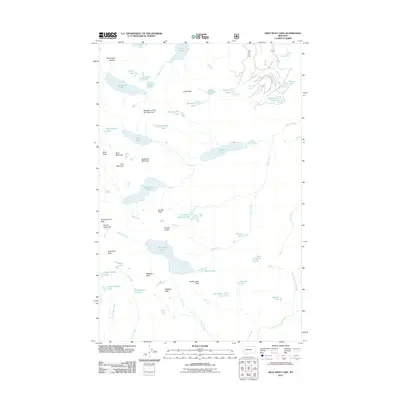
2011 Map of Gray Wolf Lake
USGS Topo · Published 2011About this map
Gray Wolf Peak stands as a prominent sentinel over a landscape defined by high-elevation water bodies and complex drainage patterns in the Mission Mountains. This 2011 survey reveals a glacial topography where small, named basins like The Angels Bathing Pool and Seepela Lake are tucked between sharp ridges. The Swan River and Glacier Creek serve as primary arteries for the region's hydrology, while names like Daughter of the Sun Mountain and Sugarloaf Mountain anchor the significant vertical relief. The map illustrates a network of connectivity through natural gaps such as Goat Pass and the evocatively named Pass of the Winds, which facilitate movement through the high-country terrain between the Swan River valley and the peaks to the west.
Find a feature on this map
54 named features on this map. Tap any name to fly to it.
Don’t see what you’re looking for? This feature index may not catch every label — zoom into the map to look around manually.
Map Details
Editions of this 2011 Gray Wolf Lake Map
This is the sole edition of this map. No revisions or reprints were ever made.
Other maps of this area

1921 · Elbow Lake
USGS Topo · 1:125,000

1955 · Choteau
USGS Topo · 1:250,000

1957 · Choteau
USGS Topo · 1:250,000

1958 · Choteau
USGS Topo · 1:250,000

1962 · Choteau
USGS Topo · 1:250,000

1965 · Upper Jocko Lake
USGS Topo · 1:24,000
1965 · Belmore Sloughs
USGS Topo · 1:24,000

1965 · Gray Wolf Lake
USGS Topo · 1:24,000

1965 · Lake Marshall
USGS Topo · 1:24,000
1965 · St Marys Lake
USGS Topo · 1:24,000