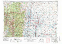
1954 Map of Greeley
USGS Topo · Published 1976About this map
The Front Range meets the agricultural plains in this mid-century survey of North-Central Colorado. Major population centers like Greeley, Fort Collins, and Boulder anchor the corridor between the high peaks of the Rocky Mountains and the irrigated valleys of the South Platte River. The landscape is defined by the elaborate water management systems feeding the region's farms, including the Windsor Reservoir and Horsetooth Reservoir. To the west, the rugged terrain of Rocky Mountain National Park culminates at Longs Peak, while the east opens into the high prairie and the distinctive Pawnee Buttes. This era shows the mature rail network of the Union Pacific Railroad and the Great Western Railway serving sugar beet and ranching districts. Local history is recorded through small plains settlements such as Grover, Keota, and Orchard, many of which highlight the proximity of the Pawnee National Grassland.
Find a feature on this map
206 named features on this map. Tap any name to fly to it.
Don’t see what you’re looking for? This feature index may not catch every label — zoom into the map to look around manually.
Map Details
Editions of this 1954 Greeley Map
3 editions found

Other maps of this area

1890 · East Denver
USGS Topo · 1:125,000

1895 · Laramie
USGS Topo · 1:125,000

1899 · West Denver
USGS Topo · 1:125,000

1902 · Laramie
USGS Topo · 1:125,000

1902 · Greeley
USGS Topo · 1:125,000

1902 · Boulder
USGS Topo · 1:62,500

1904 · Niwot
USGS Topo · 1:62,500

1904 · Boulder
USGS Topo · 1:62,500

1905 · Sherman
USGS Topo · 1:125,000

1905 · Laramie
USGS Topo · 1:125,000