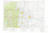
1954 Map of Greeley
USGS Topo · Published 1977About this map
The Cache la Poudre River flows from the high peaks of the Front Range through Fort Collins and Greeley, illustrating the mid-century intersection of mountain wilderness and agricultural development. This survey reveals a landscape organized by extensive irrigation and transportation, where the Union Pacific and Colorado & Southern railroads connect established farming hubs like Eaton and Fort Lupton. To the west, the boundaries of Rocky Mountain National Park and Roosevelt National Forest enclose famous summits such as Longs Peak and Hagues Peak. The map highlights a critical era for water management, detailing reservoirs like Lake Granby and Shadow Mountain Lake, which were essential to the region's transition into a major interior Colorado population center.
Find a feature on this map
199 named features on this map. Tap any name to fly to it.
Don’t see what you’re looking for? This feature index may not catch every label — zoom into the map to look around manually.
Map Details
Editions of this 1954 Greeley Map
3 editions found

Other maps of this area

1890 · East Denver
USGS Topo · 1:125,000

1895 · Laramie
USGS Topo · 1:125,000

1899 · West Denver
USGS Topo · 1:125,000

1902 · Laramie
USGS Topo · 1:125,000

1902 · Greeley
USGS Topo · 1:125,000

1902 · Boulder
USGS Topo · 1:62,500

1904 · Niwot
USGS Topo · 1:62,500

1904 · Boulder
USGS Topo · 1:62,500

1905 · Sherman
USGS Topo · 1:125,000

1905 · Laramie
USGS Topo · 1:125,000