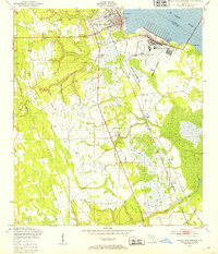
1949 Map of Green Cove Springs
USGS Topo · Published 1953About this map
Green Cove Springs sits prominently on the western bank of the St Johns River, serving as a critical hub for water, rail, and air transit in the late 1940s. The presence of the US Naval Station and Lee Outlying Field, bounded by a formal Reservation Boundary, signals the area's mid-century military importance, while the Wallace Airpark and City Dock provide civilian infrastructure for the growing community. Inland, the landscape is defined by the winding paths of Peters Creek and Clarkes Creek, punctuated by rural landmarks like Leno. A network of spiritual centers, including Old St Marys Ch and Hickory Grove Ch, reflects the established social fabric of Clay County. The Atlantic Coast Line railroad and the Shands Bridge emphasize the city's role as a gateway across the river to St. Johns County, capturing a moment of significant infrastructure development.
Find a feature on this map
24 named features on this map. Tap any name to fly to it.
Don’t see what you’re looking for? This feature index may not catch every label — zoom into the map to look around manually.
Map Details
Editions of this 1949 Green Cove Springs Map
5 editions found

Other maps of this area

1917 · Orange Park
USGS Topo · 1:62,500

1918 · Middleburg
USGS Topo · 1:62,500

1918 · Orange Park
USGS Topo · 1:62,500

1941 · Middleburg
USGS Topo · 1:62,500

1942 · Ates Creek
USGS Topo · 1:62,500

1947 · Bostwick
USGS Topo · 1:50,000

1948 · Jacksonville
USGS Topo · 1:250,000

1949 · Rice Creek
USGS Topo · 1:24,000

1949 · Bostwick
USGS Topo · 1:24,000

1949 · Green Cove Springs
USGS Topo · 1:24,000