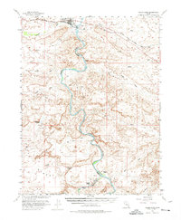
1954 Map of Green River
USGS Topo · Published 1974About this map
Green River serves as the primary hub of this arid corridor, situated where the Denver and Rio Grande Western railroad crosses the mighty Green River. Surveyed in the mid-1950s with cooperation from the Atomic Energy Commission, the map reveals a landscape defined by seasonal drainages like Saleratus Wash and Browns Wash. Remote family operations such as Ruby Ranch and Chaffin Ranch appear along the river's winding course, highlighting the isolated nature of cattle ranching and agriculture in this desert environment. Significant geological and infrastructure landmarks include the Crystal Geyser and a Landing Strip north of the town center, while a Cable Crossing downstream indicates historical transit methods across the water. The confluence of the San Rafael River and the Green River at the southern edge of the sheet illustrates the complex hydrography of the Horse Bench region.
Find a feature on this map
26 named features on this map. Tap any name to fly to it.
Don’t see what you’re looking for? This feature index may not catch every label — zoom into the map to look around manually.
Map Details
Editions of this 1954 Green River Map
5 editions found


Other maps of this area

1885 · San Rafael
USGS Topo · 1:250,000

1885 · East Tavaputs
USGS Topo · 1:250,000

1885 · La Sal
USGS Topo · 1:250,000

1886 · Price River
USGS Topo · 1:250,000

1896 · Price River
USGS Topo · 1:250,000

1951 · The Knoll
USGS Topo · 1:62,500

1952 · Tidwell 4 NE
USGS Topo · 1:24,000

1952 · Moab 3 NW
USGS Topo · 1:24,000

1954 · Tidwell 1 NE
USGS Topo · 1:24,000

1954 · Tidwell 1 SW
USGS Topo · 1:24,000