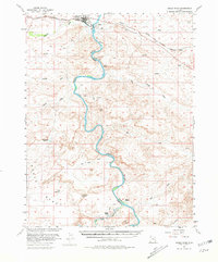
1954 Map of Green River
USGS Topo · Published 1981About this map
The Green River carves a deep, sinuous path through the high desert of the Colorado Plateau in this 1954 study, produced with cooperation from the Atomic Energy Commission. At the northern edge of the map, the town of Green River and nearby Elgin serve as a vital crossroads where the Denver and Rio Grande Western railroad and local highways span the water. A Landing Strip and Gaging Sta underscore the area's role as a logistical and hydrological monitoring hub for the desert interior.
Find a feature on this map
29 named features on this map. Tap any name to fly to it.
Don’t see what you’re looking for? This feature index may not catch every label — zoom into the map to look around manually.
Map Details
Editions of this 1954 Green River Map
5 editions found


Other maps of this area

1885 · San Rafael
USGS Topo · 1:250,000

1885 · East Tavaputs
USGS Topo · 1:250,000

1885 · La Sal
USGS Topo · 1:250,000

1886 · Price River
USGS Topo · 1:250,000

1896 · Price River
USGS Topo · 1:250,000

1951 · The Knoll
USGS Topo · 1:62,500

1952 · Tidwell 4 NE
USGS Topo · 1:24,000

1952 · Moab 3 NW
USGS Topo · 1:24,000

1954 · Tidwell 1 NE
USGS Topo · 1:24,000

1954 · Tidwell 1 SW
USGS Topo · 1:24,000